How to Read a Surf Forecast – Beginner’s Guide
In this post, you will learn how to read and interpret a surf forecast in order to find the best surf spot for your surf level.

You’ve completed your first surf lessons, and now it’s time to navigate the line-up on your own. Choosing the right surf conditions for your skill level is one of the most important factors for your progress in surfing. Local knowledge about surf spots and using a surf forecast are essential to assess the conditions and be at the right spot at the right time.
Selecting the right conditions is not only crucial for your surfing success but also for your safety in the water. For example, if the waves are too big or the water level is too low for the surf spot, it will be difficult to practice. On the other hand, paddling out into the line-up when the water is almost flat won’t do you much good either.
For experienced surfers, using a surf forecast is routine. Many surf schools and camps offer surf theory, including explanations of how to read a surf forecast. However, for beginners, it can initially feel overwhelming, and the abundance of information may seem confusing.
This article is here to help you better understand wave conditions with the help of a surf forecast.
What is a Surf Forecast?
A surf forecast is a collection of information and factors that allow surfers to evaluate conditions at a specific spot. Forecasts typically extend up to about a week in advance.
A surf forecast provides details on:
- Swell (wave height, period, direction)
- Wave strength
- Wind speed and direction
- Tides
- Sunrise and sunset times
- Weather and water temperature
- Wave quality ratings & additional spot information
Properly interpreting of these factors helps you select the best conditions for your level while understanding that there’s even more to consider beyond the data.
Which Surf Forecast Provider is the Best?
There are numerous websites and apps offering surf forecasts. Here are some of the most popular:
Surfline
Surfline is one of the best-known and most widely used surf forecast platforms. In addition to accurate forecasts, it offers live streams from surf cams. However, some content is only accessible to premium users. The app is also user-friendly and practical, allowing you to save favorite spots for quick access to current conditions in your surfing region.
Windguru
Windguru is arguably one of the most detailed forecast tools available. When you open the site, you’ll see countless numbers, colors, and shapes. Personally, I don’t find it very intuitive for an initial overview. However, it’s highly recommended if you want to perform a detailed, precise analysis. With a bit of effort, you can get used to the abundance of data.
Surf-Forecast.com
Surf-Forecast.com also covers a wide range of surf spots and is very easy to use. At the top, you can use a dropdown menu to search directly for a surf spot. If it’s not listed, check for the next closest beach. While the details are less comprehensive than Windguru, the platform often includes useful additional information and photos of the spots.
Windy & Windfinder
Windy and Windfinder provide animated visualizations of wind conditions. You can zoom in and out to get a better understanding of wind patterns and analyze forecasts for the coming days. Both services are excellent complements to other surf forecasts.
Tips for Interpretation
- You can’t go wrong with any of these platforms, but it’s worth comparing different forecasts, as they aren’t always 100% accurate. I recommend selecting one or two platforms that suit you best and regularly checking how well they predict the conditions.
- For new spots, compare forecasts from different platforms since not all providers cover every spot or list them under the same name.
- Keep in mind that even the best forecasts can be off at times. That’s why it’s a good idea to cross-reference information from at least two sources.
- In my experience, asking locals for their surf forecast recommendations and conducting your own analyses, especially when staying in one place for a while, has been invaluable. It helps improve your understanding of the conditions and builds a better sense of the forecasted values.
How to Read a Surf Forecast?
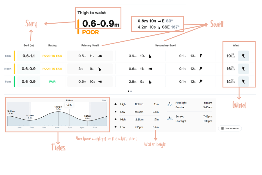
To illustrate, I will explain this using Surfline as an example. I find this platform well-organized and thus ideal for beginners.

SWELL
In simple terms, a “swell” is a wave movement generated by wind or storms on the ocean that travels in groups until it reaches a shallower coast and breaks.
(Learn here how swell and waves are created – important basics for reading a Surf Forecast)
A swell is charaterized by the following factors:

Swell Height
The height is given in meters (or feet) and is determined by measuring the wave movement (e.g., using buoys) in the ocean before it reaches the coast. These measurements capture the height of the waves from their lowest point (trough) to their highest point (crest).
Period
The swell period indicates the time in seconds between two waves. In deep water, waves with a longer period move faster than those with a shorter period. When they reach the coast, they slow down abruptly and break more powerfully.
In general: The longer the period, the more energy the wave contains, resulting in bigger, more powerful, and more defined waves.
Tips for Interpretation:
- A period up to 5 seconds usually indicates weak and less defined waves, often generated by local winds.
- A period of around 8 seconds and more suggests the wave is generated by the previously described swell. The waves are clearer, better formed, and have more energy. Espesically a swell around 12 seconds are popular within surfers.
- A period of about 17 seconds and more is rare. Only a few spots can receive waves with such a period. Caution is advised, especially for beginners, as these waves carry a lot of power!
- Be aware that a 0.5 meter swell with a period of 18 seconds can produce surf waves of up to 2 meters at the right spot. It is therefore important to understand that the period is almost more important than the height of the swell.
Swell Direction
The swell direction is indicated in degrees and shows where the waves are coming from. It represents the angle between north (0°) and the origin of the waves. For instance, a swell of 45° would come from the northeast.
Tips for Interpretation
- Swell direction is important for surfers because not every spot works with every swell direction.
- It helps to ask a local, experienced surfer which swell direction is best for the spot. Having a list of such information can assist in better interpreting a surf forecast.

Primary Swell vs. Secondary Swell
The primary swell is the wave energy with the highest potential to reach the coast, while the secondary swell has the second-highest potential to do so. If the primary and secondary swells come from the same direction and meet at the same surf spot and coastline, they can overlap and create bigger, more powerful waves.
Tips for Interpretation
- It’s possible for the primary and secondary swells not only to meet but also to switch places. This means the secondary swell becomes the primary one if the surf forecast indicates that it now has a higher potential to reach the coast. This can be seen in the Screenshot of a forecast above.
- However, it’s not uncommon for this scenario not to happen or to occur at a different time.
SURF
“Surf” refers to the average wave height in meters (or feet) that surfers can realistically expect in the line-up. This is not to be confused with swell height, which refers to the size of waves on the open ocean.
When a swell – meaning the wave movement on the open sea – reaches the beach or reef, the shallower seabed forces the wave to slow down and rise over the underwater terrain. These are the waves we see from the shore and surf on.
(Read in this article how a swell is formed and how a swell turns into a surf wave.)
A surf forecast calculates surf height using several factors, which often result in surf height differing from swell height. In the case of Surfline, the following factors are considered:
- Geographical orientation of the surf spot:
- If a moderate swell directly hits the surf spot, you can expect a larger surf. However, if the swell runs parallel to the beach (essentially by passing it), even a large swell will produce only small surf at that spot, as it is indirectly generated.
- If a moderate swell directly hits the surf spot, you can expect a larger surf. However, if the swell runs parallel to the beach (essentially by passing it), even a large swell will produce only small surf at that spot, as it is indirectly generated.
- Swell height, period, and direction
- These three elements influence the surf height significantly
- These three elements influence the surf height significantly
- The combination of swells arriving at or passing the surf spot:
- Waves interact with each other. Depending on how these movements overlap, the forecast provides a range of expected wave heights.
Tips for Interpretation
- If a small swell is forecasted, look for spots oriented directly toward that swell to maximize the energy received.
- If a large swell is forecasted and you want smaller waves, choose a spot that faces away from the swell. In this case, the swell has to bend around the land, which reduces its energy, resulting in smaller surf.
- Remember: Every swell is unique. Even if the numbers look identical, their origins may differ. Additionally, specific spot features, such as the layout of sandbanks or the shape of the reef, play a crucial role in how waves break.
WIND
In a surf forecast, you’ll also see wind strength and direction. Wind is typically measured in knots (kts) or kilometers per hour (km/h).
You can determine the type of wind suitable for a surf spot by analyzing forecasts. In general, there are three wind types: offshore, onshore, and cross-shore.
Offshore Wind:
The wind blows from land toward the waves. Surfers prefer this wind because it makes waves steeper and cleaner.
Onshore Wind
The wind blows from the sea toward the land. This pushes the waves down, often making them mushy or less defined. If the wind is strong, conditions can become very messy, resulting in poor surfing conditions.
Cross Shore Wind
The wind blows sideways onto the waves. Strong cross-shore winds can also make surfing difficult, often affecting one side of the wave more than the other.
Tips for Interpretation:
- Surfers love calm (glassy) conditions or light to moderate offshore winds, as they add more definition to the waves.
- Be cautious of strong winds, as they can create stronger currents, which may pose safety risks.
TIDES

Tides vs. Water Levels
Tides describe the interplay of ebb and flow that can be observed at the sea.

- Flow refers to the period when the water rises (from low tide to high tide).
- Ebb refers to the period when the water recedes (from high tide to low tide).
Important!
– Ebb and flow describe time periods.
– High tide, low tide, and mid tide refer to specific moments in time.
– The difference in height between high and low tide is called the tidal range.
The gravitational pull of the moon and the sun on the Earth causes tides. (You find a detailed explanation and how tides affect waves in this article!)
Tide Charts
Tide charts are usually part of a surf forecast. They indicate the times of high and low tide and allow surfers to estimate the tidal range. The strength of the tidal range depends on the alignment of the moon and the sun.
During new moon and full moon, the tidal range is at its peak. The larger the tidal range, the greater its impact on wave conditions, which you should carefully consider when choosing a spot and planning the time to surf.
- The shift from high tide to low tide takes a little over 6 hours.
- A full cycle from high tide to high tide or low tide to low tide lasts approximately 12 hours and 25 minutes.
- Since a day has only 24 hours, tides shift by about 2 × 25 minutes daily, so surfers should check the tide chart every day.
Relevance for Surfers
Tides greatly influence wave height and breaking patterns. The optimal conditions for a surf spot depend heavily on water levels and the seabed’s characteristics. While surf forecasts often provide this information, it’s better to analyze conditions yourself or consult local surfers for insights tailored to your skill level.
Tips for Interpretation
- For smaller waves, it can be helpful to surf during falling tides (e.g., mid to low tide), as waves often “spill over” and are unsurfable during high tide, especially at Beachbreaks
- Larger waves often break more gently during rising tides, which is beneficial for beginners and intermediates.
- Point- and Reef breaks: During low tide, these spots are sometimes unsurfable because the water is too shallow, posing a risk of hitting the seabed.
RATING
Many surf forecasts use algorithm-based rating systems to assess wave quality. These ratings aim to help surfers determine if conditions are good for surfing. However, the reliability of a rating can vary depending on the platform and your skill level.
For example, In my experience the star rating on Surf-Forecast.com not very helpful, especially for beginners and intermediate surfers, as even “0 stars” can mean surfable waves at certain spots.
A rating should never replace your own analysis of conditions. Personally, I find Surfline’s rating the most practical, though exceptions always exist.

Surfline’s Rating System:
Surfline explains its ratings as evaluations based on all variable conditions contributing to overall wave quality and surfability for surfers of average skill. Their 10 rating categories are:
- 1 = FLAT: Unsurfable or flat conditions. No surf.
- 2 = VERY POOR: Due to lack of surf, very poor wave shape for surfing, bad surf due to other conditions like wind, tides, or very stormy surf.
- 3 = POOR: Poor surf with some (30%) FAIR waves to ride.
- 4 = POOR to FAIR: Generally poor surf many (50%) FAIR waves to ride.
- 5 = FAIR: Very average surf with most (70%) waves rideable.
- 6 = FAIR to GOOD: Fair surf with some (30%) GOOD waves.
- 7 = GOOD: Generally fair surf with many (50%) GOOD waves.
- 8 = VERY GOOD: Generally good surf with most (70%) GOOD waves.
- 9 = GOOD to EPIC: Very good surf with many (50%) EPIC waves.
- 10 = EPIC: Incredible surf with most (70%) waves being EPIC to ride and generally some of the best surf all year.
Tips for Interpretation
- Seabed Features: Ratings rarely account for whether a spot is even surfable at low tide.
- Skill Level: A “GOOD” rating might be unsuitable for beginners if the waves are too large or steep. Conversely, a “POOR” rating might indicate ideal beginner conditions.
- Wave Consistency: A FAIR rating could mean high-quality waves that only appear in sets every 15 minutes.
Summary
A surf forecast is an essential tool for surfers to assess wave conditions. Interpreting the data takes practice, but with time, you’ll become more confident.
Use multiple platforms, consult locals, and analyze the conditions to make the most of your surf sessions. Beyond the numbers in a forecast, consider other spot-specific factors like the seabed, currents, and tides. Timing is also critical—be at the spot during the right part of the day to catch the best waves.
With experience and patience, interpreting forecasts will become an invaluable skill to improve your surfing progress.
This post was all about the analysis of a surf forecast. Now you’re ready to choose the right spot at the right time for you and make the most of your surf sessions!
(pssst….do’t forget to read the article about swell and wave creation!
Have specific questions? Feel free to reach out via the contact form or Instagram!


This actually answered my drawback, thanks!